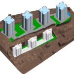
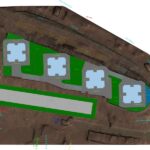
Tata Promont is located at Bangalore on an area of around 14 acres. The project required performing feasibility study for phase 2 development.
Aerial Survey to capture the site profile, converting Point Cloud data to BIM and peforming Site Analysis. The project requirement was to analyse the site to study the effect of setbacks for the construction of phase 2 towers. The requirement was to complete the study in five days. We captured the site profile using Drones. The Point Cloud data was then converted to BIM and the planned towers were modelled with required setbacks to propose the tower locations on the heavily contoured site.
The scope of the project included to capture topographical data using drone, convert the data to BIM and model the buildings at conceptual level to understand the Cut-Fill required at site.
Client:
Tata Housing
Area:
14 acres
Scope:
Aerial Survey, Point Cloud & Site Analysis
LOD:
200

